This is the first in a series of 5 posts about a section hike of the Appalachian Trail.

Last Wednesday after months of preparation my wife Alice drove me and my hiking partner, Lisa to the Skyland Lodge in Shenandoah National Park. We had a nice dinner, a great sunset, a last beer, and a last night’s sleep indoors…in a bed!

The next morning we were all up early for a huge breakfast and it was off to the trail! We drove about 9 miles south on Skyline Drive to an access point called Fishers Gap. We took some final pictures and at 9am we set out on our adventure…the wrong way! From the very start we followed a map that sent us down a fire road. We walked a few minutes when Lisa said, “I haven’t seen a white blaze yet. The white blaze is a trail marking that lets you know you’re on the AT.

We checked GPS on my cell phone and sure enough the map was a bit outdated and the access point was on the other side of Skyline Drive! 15 minutes later we were on the trail headed north for what we thought would be 20 miles a day for five days. Boy was that an unrealistic number! More on that later.
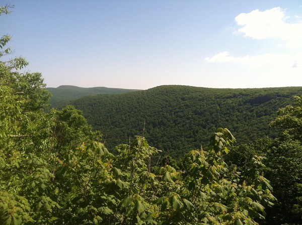
The day offered perfect weather. It was cool and dry and there was a nice breeze blowing up in the mountains. Since Fishers Gap is over 3000 feet we were immediately rewarded with a spectacular view of the Shenandoah Valley, looking westward over the town of Luray, VA. My friends from the western United States will scoff at 3,000 feet, but this was the view that kicked off the trip!

I really could hardly believe it, here I was hiking the Appalachian Trail! it was a path, a seemingly endless path through the forest. At higher elevations it is more rocky, and it is almost always going up or down. If you’re not climbing, you’re descending and when you occasionally find yourself on level ground the walking gets noticeably easier.

When you completed a climb you were almost always rewarded with a spectacular overlook. Then you might walk along the ridge for a while, or skirt the summit of a mountain and soon be headed down again.
We used hiking poles which very closely resembled ski poles. On the rockier surfaces (higher elevations) they were particularly handy on the descent.
One thing I learned early on was that my pack was too heavy. Fully loaded with water it was over 50 pounds. I knew by the end of the week I’d have figured out what I didn’t need in there!
The hiking poles were useful for that reason. The heavy pack accelerated your steps on the descent and when it got rocky the added balance of two more touch points often made the difference!

At one point we reached what appeared to be the sight of a massive rock slide. There were watermelon-sized rocks covering a 50 yard wide section of the mountain from top to about midway down and no trees or plants grew there. It opened up quite a view but it made for a tough crossing!

We hiked for a long time. Every half hour or 45 minutes stopping for water or a snack to keep our energy up. It would be about 4 hours before we were back to Skyland, where we’d had breakfast and immediately after that was the highest point in the park, Stony Man Peak! That was a tough one and by this point the heavy pack was beginning to make itself known to my shoulders.


We had identified a point at which we wanted to break for lunch. It was called the Pinnacle Picnic Ground. Fortunately we didn’t wait that long to have lunch because we didn’t get there till 3:00! Our anticipated progress of 3 miles an hour was way off and we would eventually learn that we did about 2 mph in the morning when we were fresh and slowed down to near 1 mph in the afternoon when we were tired!
We had passed a couple guys during the day who were hiking in a method they called “slackpacking”. This involved two cars and day packs. They would park one car at the end of the day’s hike, drive back to the beginning and hike it. When they got to the end they would drive car #1 back to the beginning to retrieve car #2 and retire to a hotel and restaurant for the night. They told us they would see us again before the day was over and they did indeed.
We must have looked pretty tired because they said just about a mile ahead was a really nice shelter and we should plan on staying there for the night.
The Byrd’s Nest #3 shelter was 4 miles short of our intended endpoint for the day but it was after 5:30 when we got there. We had hiked for nearly 9 hours and were exhausted and needed daylight to set up camp. Byrd’s Nest #3 would have to do.

The AT shelters although rustic are generally pretty charming and this one was indeed a welcome sight. We decided we would camp in tents nearby but this would be the gathering spot to meet other hikers and dine together. We set up our tents and proceeded to fix dinner. This first required a trip to the spring to get more water. The spring was about a quarter-mile down the mountain which meant an additional half mile round trip for water!


Dinner, however, was fantastic! This is doubtless one of the reasons my pack was so heavy but we had curried lentils with salmon (from a foil pouch) over them. After a long day of hiking this was just about the best meal I’d ever had!

We watched a gorgeous sunset from the top of the ridge, hung our food up in the “bear pole” and got into our tents and waited for it to get dark. A good night’s sleep was going to be really important. Important, yes but easy? Not so much.

I heard every leaf rustle. At points I swear I heard something sniffing around the tent and all night long I waited for some critter to cause trouble. It never happened, and that discomfort would dissipate a little each night but that first night did not include a lot of deep REM sleep!
Nonetheless our first day was over and other than fatigue, it had been a great day. We were 4 miles behind our goal already, but we’d worry about that later.
We had already met a few characters and traded trail names. “Strollin'” was a through-hiker who had started in Georgia in February. In our shelter was a pair of cousins who had, over the years hiked the entire trail in sections. “Shag-Bark” and “Katydid” were both from Pittsburgh and each had their own families but shared a love for hiking and had done trips like this for decades. They had a son and a nephew with them. One had the trail name “Moby” and the other had an actual name that beat any trail name, Forest! They were nice and were sleeping in the shelter in hammocks. In the morning when we woke up we discovered another guy, “Sparrow” had glided in during the night and was through hiking at a rate of 25 miles per day!
My next post will detail Day 2, which marked the “low point” of the trip. Stay tuned!
π

Thank you for sharing, it is so interesting!
LikeLike
Thank you Mom!
LikeLike